
Connecting You
to Your City
To sign-up for Blue Line project updates,
please follow the link below.

To sign-up for Blue Line project updates,
please follow the link below.
Blue Line Summary
The Blue Line will run 24 miles, connecting the Indianapolis International Airport to the Town of Cumberland via downtown Indianapolis along I-70, Holt Road and Washington Street. The line is scheduled to open for service in 2028. Once complete, it will offer faster, safer and more reliable service.
Beyond transit, the project also brings new street paving, improved sidewalks and pedestrian crossings, and ADA-compliant curb ramps to the Washington Street corridor, making it safer and more accessible for all.
IndyGo is committed to supporting residents, businesses and neighborhoods along the corridor. To access resources and stay updated on project construction, sign up for the Blue Line newsletter here.
Blue Line Construction
IndyGo’s work on the Blue Line, its third Bus Rapid Transit (BRT) line, has partially closed two parts of Washington Street. See major motorist detours and rider maps below for more details. To learn more about utility work along the Blue Line, click here.
Experiencing a water or natural gas outage? Many underground utility lines must be relocated before Blue Line construction crews can fully begin their work. Citizens coordinates the required relocation of water, sewer and natural gas lines. This work may require a temporary service disconnection (generally lasting fewer than eight hours), but crews will work to reconnect service as soon as possible. Citizens hosts an online map of reported utility outages as well as a map of ongoing construction which includes utility work for the Blue Line. While not all outages or construction areas may be entirely represented on these maps, they are good tools to determine whether the outage or construction you are encountering is related to Blue Line.
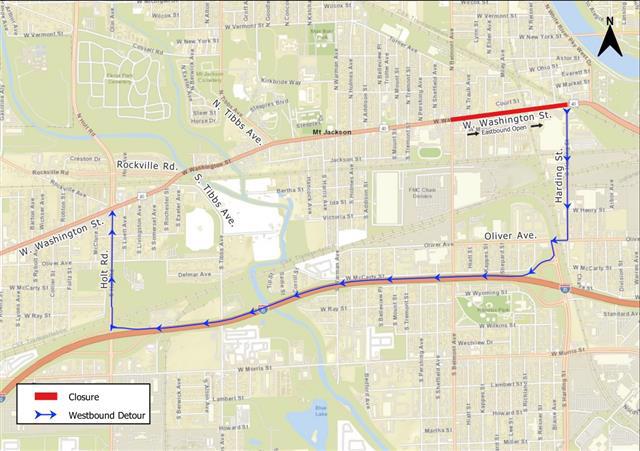
Westbound lanes between Belmont Avenue and Harding Street will be closed to through traffic. Motorists driving westbound will detour around the closure using Harding Street, I-70 and Holt Road. One eastbound lane will remain open, maintaining local access to residences and businesses along this portion of Washington Street.
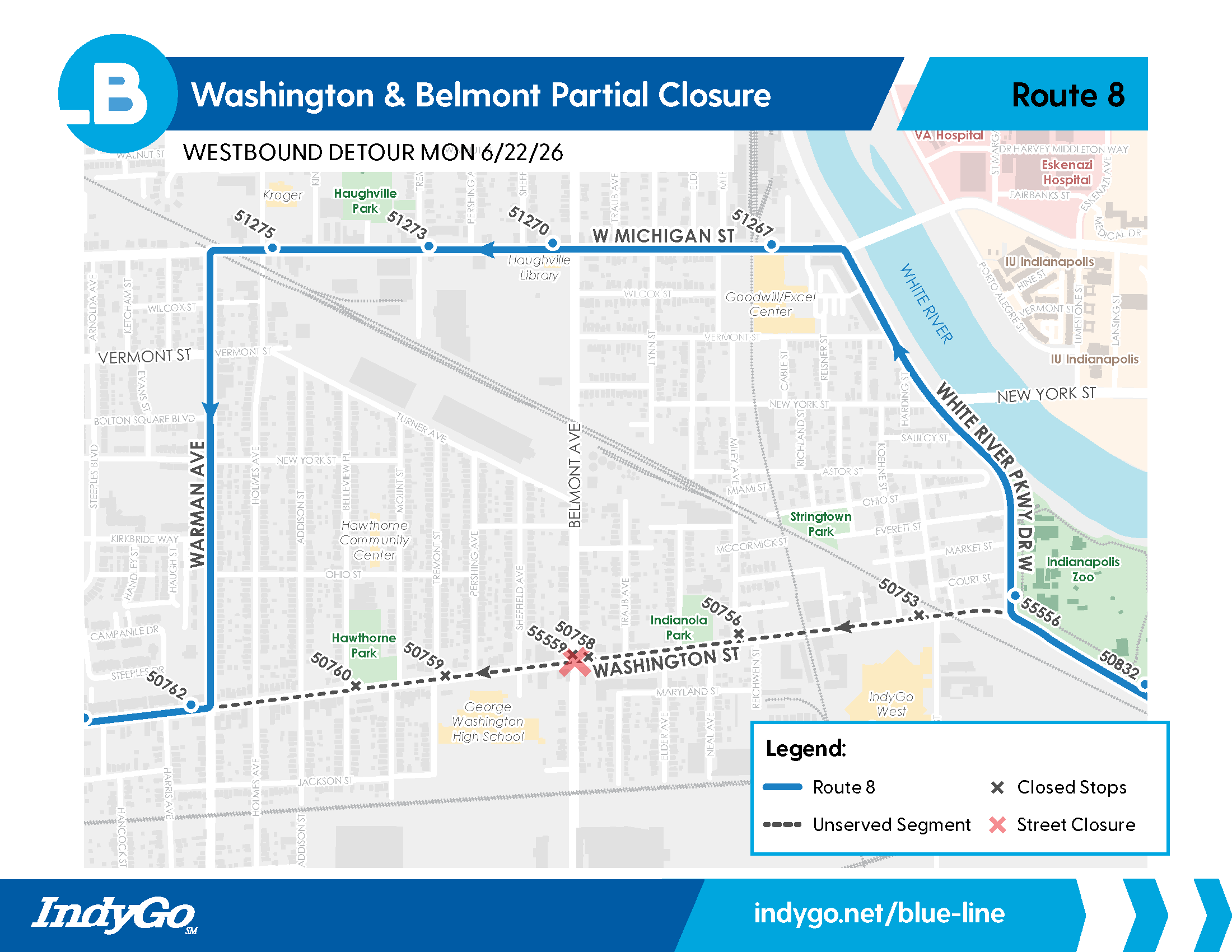
On or after June 22, 2026, IndyGo’s Route 8 detour for the Washington Street closure between Warman Avenue and Harding Street will change to using North White River Parkway, Michigan Street and Warman Avenue. All westbound bus stops (Stops 50760, 50759, 55559, 50758, 50756 and 50753) along Washington Street, between Warman Avenue and Harding Street are closed. Temporary stops are available near the intersections of Washington and Harding streets and Michigan and Cable streets (Stop 51267).
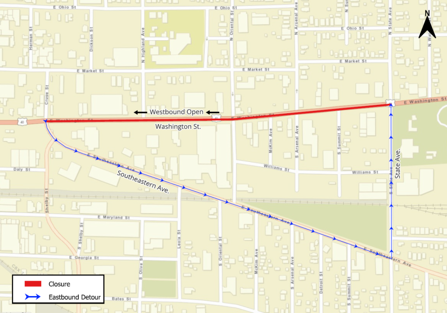
Eastbound traffic will be detoured south on Southeastern Avenue and north on State Avenue to Washington Street. Westbound access on Washington Street will be maintained during construction.
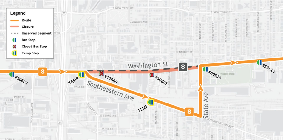
Washington Street is closed from Southeastern to State avenues. IndyGo’s Route 8 is on detour using Southeastern and State avenues. Bus stops 50605 and 50607 are closed. Temporary stops are available near State Avenue, Oriental Street, Southeastern Avenue and Washington and Cruse streets.
*Last updated July 2026